2020-06-14
Quantix Recon to Provide Actionable Intelligence
AeroVironment, Inc. recently announced the availability of Quantix Recon, a lightweight, rapidly deployable, fully-automated reconnaissance solution. It can deliver high resolution, georeferenced terrain, vegetation and infrastructure imagery, providing ground forces with on-demand actionable intelligence.
When ground forces advance on the battlefield or when law enforcement must mobilise in times of potential danger, or first responders need to rush to find the lost or injured—they can all count on AeroVironment’s small Unmanned Aircraft Systems (UAS). It’s a certainty that comes in the way of real-time video and thermal data, covering a wide area, and wirelessly transmitted to a hand-held ground control unit. Delivering systems with flexibility and capability, AeroVironment’s specialised portfolio of UAS provide critical intelligence and high precision strike capabilities that can mean the difference between failure and certain success. AeroVironment’s new Quantix Recon is one such UAS, which proves to be valuable to ground forces.
Hybrid Design
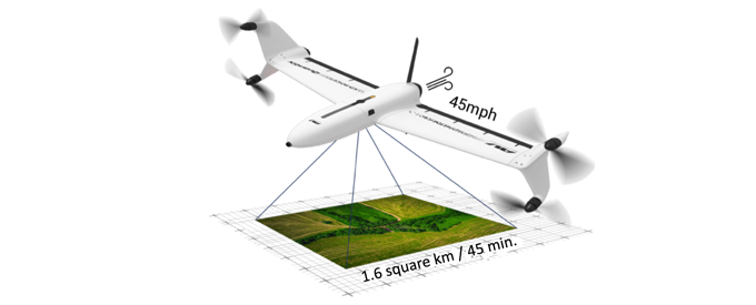
With its unique hybrid VTOL design, Quantix Recon combines the vertical take-off and landing advantages of a multirotor drone with the range, speed and efficiency of a fixed-wing unmanned aircraft. Featuring fully automated flight operation, Quantix Recon surveys up to 1.6 square kilometres (0.6 square miles), or 20 linear kilometres (12.4 miles) per 45-minute single battery flight. This is four times the coverage of most quadcopters.
Multiple automated reconnaissance mode options allow users to choose between line (route), area and waypoint targeted data capture. Collected aerial imagery data is compatible with a wide range of available geographic information system (GIS) analytical tools to facilitate further analysis.
“AeroVironment’s Quantix Recon is a low-cost reconnaissance solution that can be in the air within minutes, capturing high-resolution georeferenced imagery of hard to access areas or dynamically changing environments,” said Rick Pedigo, vice president of sales and business development for AeroVironment. “Because it does not rely on radio signals during flight, Quantix Recon offers greater stealth for concealed operations and is unaffected by radio frequency jammers, providing greater protection for frontline troops while reducing cognitive load.”
Simple to use, Quantix Recon UAV is hands-free with five optional flight altitudes, ranging from 150 feet to 800 feet. The automated operation makes the solution easy for users to vary the coverage area and image resolution to suit their aerial reconnaissance needs.
Quantix Recon is equipped with dual 18-megapixel cameras that can capture both high resolution true colour and multispectral georeferenced imagery. Powerful, on-board processing allows users to immediately view the high-resolution geospatial imagery on the included operating tablet as soon as the aircraft lands, requiring no other devices, Internet or software. And, through the operating tablet’s Quick-Look HD app feature, users can pinch and zoom navigation down to centimetre-level ground sampling distance, enabling them to pinpoint and react to critical issues with precision and speed.
Mapping and scouting tasks are effortless with its fully-automated take-off, flight and landing functions — even first-time users can successfully operate it. Furthermore, Quantix Recon delivers accurate, up-to-date maps within minutes for quick mission planning and verification.
Due to its innovative design, Quantix Recon outperforms traditional quadcopters in range and efficiency. That means teams can cover more ground faster and obtain aerial maps of remote, inaccessible areas and rapidly changing environments to ensure the safety of ground troops. It allows for easy mission planning on the included Android tablet and collects timely and accurate imagery of any point of interest.
Silent Mode and Image Formats
Quantix Recon’s RF Silent Mode when activated after launch enables it to fly undetected and undeterred by jammers. It flies the pre-programmed mission stored on the SD enabling data collection up to 20 km out and back.
Moreover, Quantix Recon Data is available in non-proprietary (GeoTIFF) file format for integration into a wide range of stitching and geographic information system (GIS) analytics tools to facilitate further geospatial analysis if required.


No Comments