2017-09-07
INDAGO 3 UNMANNED AERIAL SYSTEM
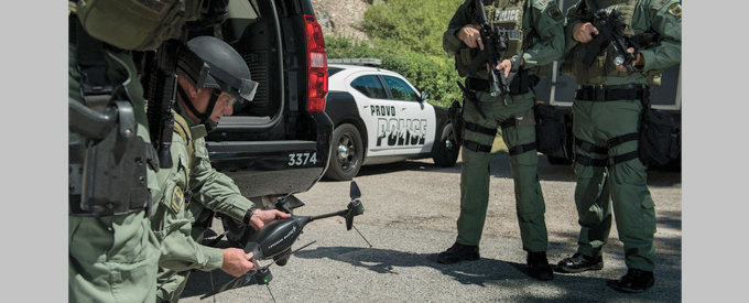
Lockheed Martin’s Procerus Technologies Indago quadrotor unmanned aerial system (UAS) goes beyond the capabilities of the average drone. With market-leading endurance and quick deployability, Indago gives civilians and war fighters an eye-in-the sky in just minutes.The UAS, along with its payload options and advanced ground control software, helps accomplish diverse missions. Lockheed Martin has five decades of experience in unmanned and autonomous systems for air, land and sea.
The latest Indago 3 now enables military customers to complete sensitive intelligence, surveillance and reconnaissance (ISR) missions securely with the addition of TrellisWare Technologies MANET software products.
Compared to previous versions Indago 3 offers mproved propulsion technology, reducing noise signature and extending flight time. It offers a military-grade encrypted and secure data link, as well as secure, mesh capable video dissemination across multi-node networks and extended range radio.
Along with low acoustic and visual signature during start-up and flight, it’s also available in haze grey, minimising visual detection during missions. Depending on payloads, Indago 3 has a flight time of up to 50 minutes, a range of 10 kilometers and a cruise speed of 25 mph. It can operate at temperatures as low as 30 degrees below zero, and as high as 120 degrees.
“Indago 3 gives a quiet, durable, long-range system to complete sensitive operations with a small UAS,” said Rich Bonnett, Indago programme manager, Lockheed Martin unmanned systems. “Our military customers tell us that Indago 3 gives them superior security, reliability and ruggedness compared to other UAS.”
Indago 3’s minimal radio frequency footprint is achieved by the TW-600 Ocelot module by TrellisWare.
“The Ocelot module, equipped with TrellisWare’s robust TSM networking, is built specifically for integration into UAS,” said Matt Fallows, Director of Applications & Systems at TrellisWare.
The collapsible Indago weighs less than 5 lbs. and folds into a man-packable unit that requires no tools for assembly. Indago can be unfolded in 60 seconds, and airborne in just 2.5 minutes. Indago 3 offers additional durability for operation in harsh environments and weather conditions.
UAV Whatever the Weather
In tandem with the UAV platform, Indago includes a weather-resistant wireless hand controller; an easy-to-use interface for untethered UAV operation.
The wireless hand controller can be used for small unmanned aircraft, whether fixed wing or VTOL, providing on-board video recording and high resolution still images. With four hours runtime, the 3.5 lbs hand controller has a large touchscreen, running on Windows OS.
It has a full spectrum of features – a “Virtual Cockpit” user-friendly mapping interface; powerful mission planning tools; in-flight re-tasking; full waypoint navigation; a Wi-Fi link to laptop and video dissemination and integrated GPS and 4G LTE connectivity.
A Neat, Elegant Package
Kestrel Autopilot integrates all flight sensors, communication and payload interfaces into a neat, elegant package. It provides high-bandwidth control for unparalleled stability in poor weather; aggressive climb, descent and forward flight maneuver capability and expandable avionics architecture enable a wide range of integrated payloads and sensors.
Indago goes beyond the normal stable, capable UAV design. Features include an extended hover and fast-forward flight capability, providing a quick aerial reconnaissance capability in crowded areas, unreachable by fixed-wing unmanned aircraft.
The payload system also separates Indago from the average drone. Featuring a quick disconnect adapter, operator can choose appropriate payloads that suit the mission.
Indago In Real Life: Case Studies
Firefighting
Indago can operate through wind, smoke, dust and flames to help firefighters identify the intensity and location of hot spots, as well as provide information on areas where people and property are at risk.
Brush fires in Western Australia threaten lives and property, but manned aircraft support is only available to ground firefighters during daylight hours, leaving a gap in aerial information and support.
The ground firefighting team required a rugged system with night lighting, could be integrated with an advanced ground control station, and deliver 24/7 data on fire intensity and location of hot spots.
Indago enabled firefighters to maximise the effectiveness of nighttime operations. It streamed live video from its thermal sensor to ground operators, who used the data to identify hot spots, fire location and intensity, and people and property who were at risk.
It helped save around 100 homes, worth more than $50 million. Using Indago, firefighters reduced the size and duration of the fire, reduce the impact on the community, and realize cost savings in managing the response.
Project Lifesaver
Lives are at stake when individuals with Alzheimer’s disease, Autism and Down Syndrome wander from their homes. Project Lifesaver International is a public safety nonprofit organization that works with first responders to return these individuals to their homes or facilities, and the organization has conducted more than 3,000 rescues in the past 16 years. Time is critical when people are missing, and airborne search and rescue can be costly and time consuming.
To improve its ability to locate missing individuals, Project Lifesaver required a system that could be rapidly deployed and needed to carry a unique payload with location antenna and a tracking system.
Indago can be stored in any squad car and extends Project Lifesaver search areas from one and a half miles to well over seven miles.
Indago is paired with Project Lifesaver’s electronic location equipment to find special needs individuals who may wander. Upon receiving a distress call, operators can rapidly deploy Indago to locate missing individuals.
Indago reduces response time and increases the efficiency of search efforts when time is critical.
Disaster Relief
Following the devastation of Cyclone Pam in Vanuatu, the United National World Bank and Vanuatu government required rapid damage assessment, without putting further strain on the limited ground and aviation assets available to the response effort.
A system needed to rapidly deploy in challenging terrain and remained stable in adverse weather conditions.
Heliwest Group deployed Indago to survey 50 sites across nine remote islands. The team conducted 126 separate missions over 12 days to capture oblique imagery, video, and ortho-mapping. Its flexibility and small logistics footprint allowed Heliwest to deploy a full system while remaining mobile.
First Response
After a fire, an accident or in hazardous search-and-rescue operations, first responders need to quickly assess the situation and determine how to assist or find people in dangerous situations. The need to rapidly capture evidence, record accident and crime scenes, search the area for evidence, and provide first responder safety.
The various payloads available with UAS can expedite the search process based on mission requirements.
To improve employee safety, reduce cost of inspections and decrease time required to complete inspections, first responders require compact, lightweight and easily deployed systems, that can carry a unique payload based on needs.
In addition to capturing high resolution images and video, Indago can record and live-stream data with a smooth, stable video capability, day or night. This payload can not only gather thermal images, it also has a built-in laser illuminator which are crucial in search and rescue operations in rugged terrain such as with missing hunters or hikers.
Indago can capture detailed images from 300 feet away and can be used in all weather, even when manned aircraft are grounded. Using an Indago instead of, or to supplement, other aerial assets leads to improved safety and cost savings in managing response to a fire, accident or missing person case.


No Comments